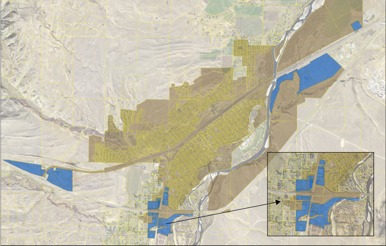
A map of the proposed district can be found here.
The following addresses/ legal descriptions are for the forty-nine (49) commercially zoned parcels in the City of Livingston proposed to be included in the Gateway Overlay Zoning District:
5290 US Hwy 89S; C.O.S. 2132, Parcel 4 (ID 49080305401100000); C.O.S. 2307 RB, PARCEL 4A (ID 49080307401600000); 5288 US Hwy 89S; 2420 Park Street S; 5288 US Hwy 89S; 23 West End Road; 2800 E Park Street; 320 Alpenglow Lane; 2410 Park Street S; C.O.S. 2668 RB, PARCEL 1C (ID 49080308301200000); C.O.S. 2318, PARCEL 2 (ID 49080222201250000); C.O.S. 2318, PARCEL 3, POR NW4 N OF HWY (ID 49080221201100000); C.O.S. 2748 RB, PARCEL 1A (ID 49080222204010000); 207 Antelope Drive; 100 PFL Way; 2128 W Park Street; 2120 Park Street S; SUBDIVISION 136 (BUTTREYS), LOT 2 (ID 49080223403070000); 2000 W Park Street; 114 Loves Lane; 5 Pronghorn Drive; 3 Pronghorn Drive; 2050 Park Street S; 104 Centennial Drive; 106, 108, 110 Centennial Drive; 105 Centennial Drive; 101 Centennial Drive; 103 Centennial Drive; 69 Willow Drive; 5 Rogers Lane; 105 Rogers Lane; 111 Rogers Lane; 9, 11, 13 Rogers Lane; 21 Rogers Lane; 102 B Rogers Lane; 102 A Rogers Lane; 1701 W Park Street; 1623 W Park Street; 1621 W Park Street; 1625 W Park Street; 1601 W Park Street; 1515 W Park Street; 1415 W Park Street; 1429 W Crawford Street; 1427 W Crawford Street; 1415 W Park Street; 1409 W Park Street; 16 Loves Lane.
Key Dates for Public Input
- June 24, 5:30 pm - Consolidated Land Use Board (Zoning Commission)- Public Hearing
- July 8, 4:30 pm - deadline to file protest petitions
- July 16 – City Commission 1st Reading
- August 6- City Commission 2nd Reading
In 2021, the City adopted a Growth Policy that included recommendations for the establishment of Community Gateways at key entry and exit points at the periphery of City limits (see Exhibit 3.2- Special Districts Map in the Growth Policy). The three areas identified for Community Gateways are: the Western Gateway (near the Hwy 10/ Exit 330 interchange); the Eastern Gateway (near the US Hwy 89S/ Exit 337 interchange); and the Southern Gateway (near the I-90/ Exit 333 interchange). To date, no Gateway Overlay Districts have been established or incorporated into the Zoning Code.
On February 26, 2024, the City of Livingston hosted a public Gateways Visioning Workshop that served to continue community discussion around Gateways that originated during the planning process for the 2021 Growth Policy. In the coming year, the City will embark on a comprehensive Zoning Code Update process to align the Zoning Code with the guidance and recommendations found in the Growth Policy. Included in the Gateways Visioning Workshop memo is the recommendation that, while the Code Update is underway, the City should utilize the existing Building Design Standards in Section 30.46 of the Zoning Code, along with Growth Policy guidance, as a tool to encourage commercial development/ redevelopment in Gateway Areas that contributes to the vision of the community and reflects the unique character of the City of Livingston.
The purpose of the proposed Zoning Map Amendment is to create a Gateway Overlay Zoning District that includes the locations of community gateway areas at the entrances to Livingston. The proposed Gateway Overlay District is based on the Exhibit 3.2- Special Districts Map in the 2021 Growth Policy; however, only commercially zoned parcels located within the municipal boundaries of the City of Livingston are included in this Map Amendment.
The creation of a Gateway Overlay Zoning District supports the following goal, objective and strategies in the 2021 Growth Policy:
- Goal 2.1: Preserve and enhance Livingston’s unique community character.
- Objective 2.1.1: Establish community gateways to indicate entrances into Livingston and celebrate its character.
- Strategy 2.1.1.1: Identify key roadway and non-motorized entry points – or Gateways – into Livingston.
- Strategy 2.1.1.2: Review, update, and enforce the policies, procedures, and building design guidelines in Livingston’s gateways.
- Strategy 2.1.1.3: Explore adopting design overlay zones in gateways.
- Strategy 2.1.1.4: Develop effective wayfinding signage for locals and tourists to easily find destinations, trails and parks, and parking within and nearby gateways.
A public hearing before the City of Livingston Land Use Board (Zoning Commission) concerning this Zoning Map Amendment will be held at 5:30 p.m. on Monday June 24, 2024 at 414 E. Callender Street in the Community Room. The Land Use Board will make a recommendation to the City Commission regarding the proposed Zoning Map Amendment.
Owners of all parcels within 300 feet of the proposed district (both within the municipal limits of Livingston and in unincorporated Park County) are included in this notice. However, only parcels located within the City of Livingston municipal boundaries are included in the proposed Gateway Overlay Zoning District.
Protest petitions must be filed with the City of Livingston no later than 4:30 pm on Monday July 8, 2024. Protest petitions can be emailed to planning@livingstonmontana.org or dropped off in person at City Hall located at 220 E. Park Street.
For further information, please contact the City Planning Office at (406) 222-4903 or planning@livingstonmontana.org.